 Mt Waterman
 Bogus Basin

 WebCams

Coaster
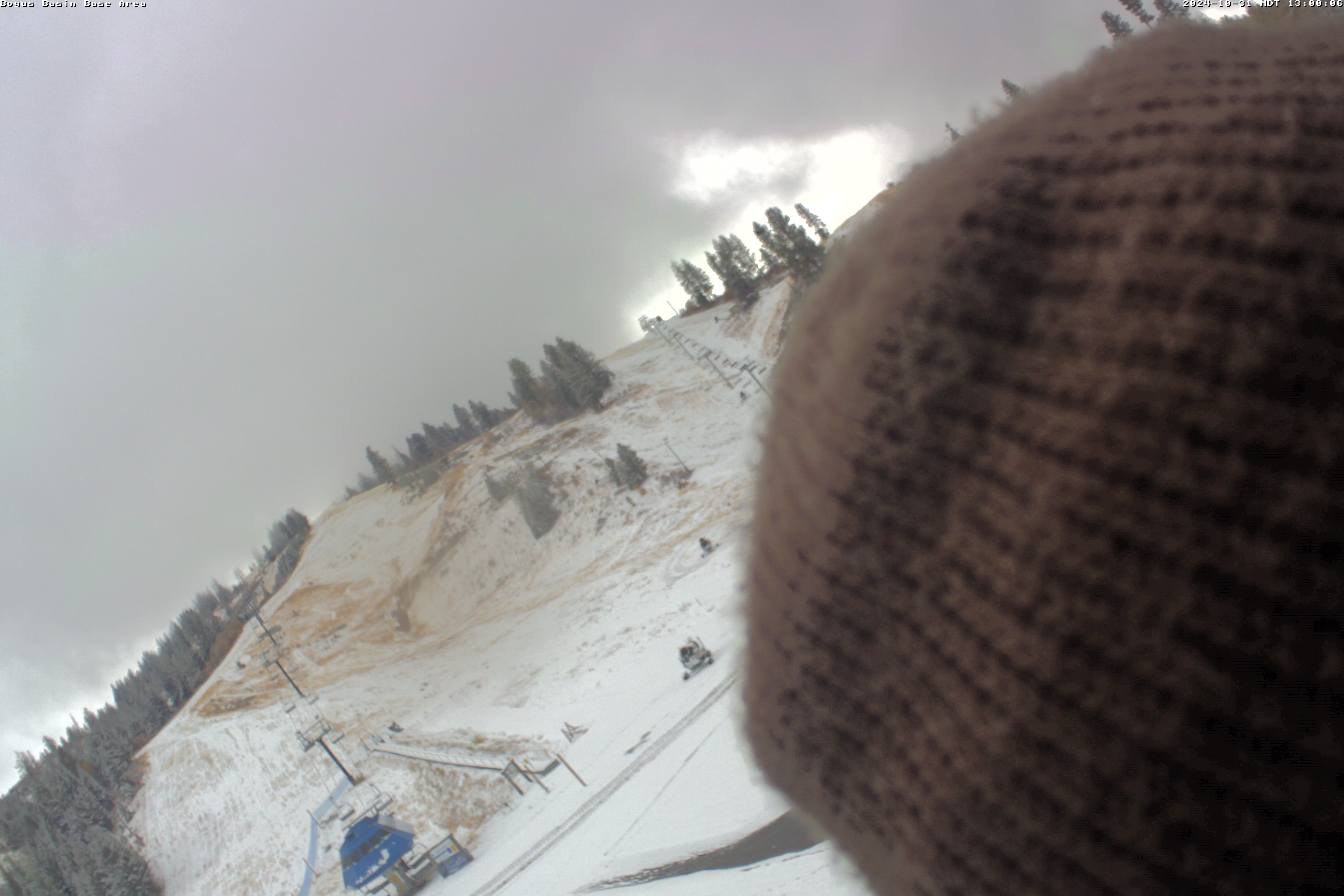
Base Area
Snow Stake
MONDAY
Jun 8

55° / 37°

15 - 25
mph
 0
0
TUESDAY
Jun 9
47° / 35°

10 - 20
mph
0
WEDNESDAY
Jun 10
45° / 30°
10 - 18
mph
0
THURSDAY
Jun 11

59° / 31°

8 - 16
mph
0
FRIDAY
Jun 12
68° / 40°
5 - 15
mph
0
SATURDAY
Jun 13

72° / 44°
5 - 15
mph
0
SUNDAY
Jun 14
39° / 36°
9 - 17
mph
0
The high at the base (BOGI1, 6,340ft) yesterday was 47f, pretty cold for June... 37f this am... Strong low pressure moves in... Mostly cloudy (partly sunny) through the morning, chilly, becoming cloudy and windy in the afternoon and evening (4pm-overnight), through overnight, with some moderate to heavy rain expected initially, best chances in the evening, then lighter showers overnight. Isolated thunderstorms are expected also. Strong low pressure moves in...
Snow above 9,000 feet toward Tuesday morning
Potential Precip:
0.35 to 0.75, 100% chance beginning 4pm
Hi: 55°Low: 37°
6,287 feet to 7610 feet
Winds SE at 10 to 20 mph in the morning, becoming SW at 15 to 25 gusts to 40 mph in the afternoon through overnight.
Cloudy becoming mostly cloudy at times continuing through overnight, with periods of snow expected at any time.
Heavy snow during the day, becoming light in the evening and moderate overnight. Snowfall is forecast to be 3 to 6 during the day, and 3 to 5 inches in the evening and overnight.
Potential Precip:
0.33 to 1.64
Hi: 32°Low: 27°
6,287 feet to 7610 feet
Winds W at 23 to 34 mph with gusts to 40 through the day, becoming W at 30 to 41 mph overnight.
Mostly cloudy to cloudy and colder (much cooler than average) with windy conditions and scattered showers through the early afternoon as strong low pressure moves across the Northwest US. Snow levels could dip below 8,000ft and dust the summit of Bogus Basin with some snow. Skies clear to partly cloudy in the later afternoon, evening.
A trace up top
Potential Precip:
0.05 to 0.25, 70% chance
Hi: 47°Low: 35°
3,445 feet to 6170 feet
Winds W at 8 to 16 mph through the morning, becoming WNW at 10 to 20 mph with gusts to 30 in the afternoon onward.
Partly cloudy becoming clear in the late morning continuing through overnight.
Scattered snow showers possible.
Potential Precip:
0.02 to 0.09
Hi: 26°Low: 22°
3,445 feet to 6170 feet
Winds W at 16 to 27 mph in the morning, becoming W at 14 to 23 mph in the afternoon, and then W at 9 to 18 mph overnight.
Low pressure and unsettled conditions continue across the Northwest US... Partly cloudy and cold (below freezing to start) with windy conditions.
No snow
None
Hi: 45°Low: 30°
6,114 feet to 7442 feet
Winds NW at 10 to 18 mph with gusts to 28.
Partly cloudy becoming mostly cloudy in the late morning continuing through overnight, with windy conditions at times.
No snow.
No precipitation expected.
Hi: 31°Low: 27°
6,114 feet to 7442 feet
Winds SW at 8 to 16 mph in the morning, becoming W at 11 to 20 mph in the afternoon through overnight.
Mostly clear and cool but milder, breezy and drier as high pressure ridging builds in.
No snow
None
Hi: 59°Low: 31°
6,862 feet to 9316 feet
Winds NW at 8 to 16 mph through the day.
Clear becoming cloudy at times continuing through overnight, with windy conditions at times.
No snow.
No precipitation expected.
Hi: 37°Low: 32°
6,862 feet to 9316 feet
Winds W at 12 to 21 mph with gusts to 27 in the morning, becoming W at 18 to 29 mph in the afternoon, and then W at 13 to 24 mph with gusts to 33 overnight.
Mostly clear and warmer, less wind, dry (building high pressure ridging across the Northwest US).
No snow
None
Hi: 68°Low: 40°
7,314 feet to 9282 feet
Winds NW at 4 to 12 mph through the day.
Cloudy becoming mostly cloudy at times continuing through overnight, with periods of snow developing in the evening through overnight.
Periods of light snow throughout the day and overnight. Snowfall is forecast to be a trace amount.
Potential Precip:
0.01 to 0.07
Hi: 37°Low: 31°
7,314 feet to 9282 feet
Winds SW at 11 to 20 mph throughout the day and into overnight.
Clear and warmer, beautiful weather, breezy.
No snow.
No precipitation expected.
Hi: 72°Low: 44°
7,344 feet to 8394 feet
Winds NW at 5 to 15 mph gusts to 20 mph.
Cloudy becoming clear at times continuing through overnight, with periods of snow expected in the morning through evening.
Periods of light to moderate snow throughout the day. Snowfall is forecast to be 1 to 2 inches.
Potential Precip:
0.07 to 0.36
Hi: 35°Low: 31°
7,344 feet to 8394 feet
Winds SW at 7 to 15 mph through the day, becoming variable at 7 to 15 mph overnight.
Clear becoming mostly clear at times continuing through overnight, with windy conditions at times.
No snow.
No precipitation expected.
Hi: 44°Low: 36°
8,119 feet to 10063 feet
Winds variable at 8 to 16 mph through the day, becoming variable at 5 to 13 mph overnight.
Clear becoming mostly clear at times continuing through overnight, with windy conditions at times.
No snow.
No precipitation expected.
Hi: 37°Low: 34°
8,119 feet to 10063 feet
Winds SE at 9 to 17 mph through the day, becoming variable at 9 to 17 mph overnight.
 Sunrise & Sunset

Lunar Calendar


 Snow Maps and Weather Stations in the Area
 ![]() 12 - 15in, past 6 days. Snow surface is packed powder and machine groomed
12 - 15in, past 6 days. Snow surface is packed powder and machine groomed
Snow report provided by SnoCountry
Plan your future trip using our temperature, snowfall, snow depth, and precipitation tool
 Day |
 High Temperatures |
 Low Temperatures |
 Precipitation |
 Snowfall |
 Snow Depth |
||||||||||||||
|---|---|---|---|---|---|---|---|---|---|---|---|---|---|---|---|---|---|---|---|
| Avg | High | Year | Low | Year | Avg | High | Year | Low | Year | Avg | Max | Year | Avg | Max | Year | Avg | Max | Year | |
| 1 | 59 | 69 | 1956 | 46 | 1967 | 41 | 52 | 1957 | 21 | 1955 | 0.046 | 0.45 | 1967 | 0.00 | 0.0 | 1970 | 0.0 | T | 1962 |
| 2 | 61 | 72 | 1970 | 50 | 1967 | 42 | 56 | 1970 | 28 | 1963 | 0.009 | 0.07 | 1958 | 0.00 | 0.0 | 1970 | 0.0 | T | 1962 |
| 3 | 62 | 75 | 1970 | 47 | 1958 | 44 | 60 | 1970 | 22 | 1962 | 0.055 | 0.35 | 1963 | 0.07 | 1.0 | 1962 | 0.0 | T | 1962 |
| 4 | 61 | 79 | 1969 | 41 | 1962 | 41 | 62 | 1970 | 21 | 1962 | 0.040 | 0.27 | 1963 | 0.03 | 0.5 | 1956 | 0.1 | 1 | 1956 |
| 5 | 61 | 77 | 1969 | 40 | 1963 | 44 | 59 | 1969 | 23 | 1956 | 0.104 | 1.30 | 1963 | 0.07 | 1.0 | 1956 | 0.0 | T | 1962 |
| 6 | 62 | 72 | 1970 | 47 | 1956 | 44 | 57 | 1970 | 27 | 1962 | 0.030 | 0.35 | 1964 | 0.00 | 0.0 | 1970 | 0.0 | T | 1962 |
| 7 | 60 | 72 | 1970 | 44 | 1964 | 43 | 54 | 1969 | 34 | 1962 | 0.036 | 0.50 | 1964 | 0.00 | 0.0 | 1970 | 0.0 | T | 1962 |
| 8 | 62 | 75 | 1955 | 45 | 1964 | 46 | 58 | 1955 | 38 | 1963 | 0.038 | 0.27 | 1957 | 0.00 | 0.0 | 1970 | 0.0 | T | 1962 |
| 9 | 60 | 73 | 1955 | 46 | 1958 | 43 | 60 | 1956 | 31 | 1963 | 0.184 | 1.21 | 1970 | T | T | 1963 | 0.0 | T | 1962 |
| 10 | 59 | 72 | 1965 | 43 | 1964 | 43 | 59 | 1956 | 31 | 1964 | 0.027 | 0.34 | 1969 | 0.00 | 0.0 | 1970 | 0.0 | T | 1962 |
| 11 | 61 | 75 | 1965 | 48 | 1970 | 43 | 55 | 1965 | 30 | 1966 | 0.009 | 0.11 | 1969 | 0.00 | 0.0 | 1970 | 0.0 | T | 1962 |
| 12 | 60 | 77 | 1959 | 47 | 1970 | 43 | 59 | 1959 | 30 | 1965 | 0.078 | 0.91 | 1958 | 0.00 | 0.0 | 1970 | 0.0 | T | 1962 |
| 13 | 61 | 73 | 1959 | 47 | 1970 | 43 | 60 | 1959 | 26 | 1965 | 0.048 | 0.20 | 1965 | 0.00 | 0.0 | 1970 | 0.0 | T | 1962 |
| 14 | 60 | 73 | 1961 | 43 | 1957 | 43 | 56 | 1961 | 29 | 1965 | 0.040 | 0.22 | 1965 | 0.03 | 0.5 | 1957 | 0.0 | T | 1962 |
| 15 | 58 | 77 | 1961 | 39 | 1957 | 43 | 59 | 1961 | 28 | 1957 | 0.241 | 1.17 | 1956 | 0.20 | 3.0 | 1957 | 0.1 | 1 | 1957 |
| 16 | 61 | 79 | 1961 | 45 | 1956 | 44 | 63 | 1961 | 27 | 1956 | 0.123 | 0.75 | 1964 | 0.33 | 5.0 | 1956 | 0.0 | T | 1962 |
| 17 | 64 | 82 | 1961 | 49 | 1964 | 47 | 67 | 1961 | 31 | 1956 | T | T | 1965 | 0.00 | 0.0 | 1970 | 0.0 | 0 | 1970 |
| 18 | 68 | 80 | 1961 | 49 | 1964 | 48 | 65 | 1961 | 33 | 1964 | 0.011 | 0.15 | 1964 | 0.00 | 0.0 | 1970 | 0.0 | 0 | 1970 |
| 19 | 68 | 78 | 1961 | 42 | 1964 | 51 | 66 | 1959 | 30 | 1964 | 0.012 | 0.08 | 1962 | T | T | 1964 | 0.0 | 0 | 1970 |
| 20 | 68 | 81 | 1961 | 53 | 1964 | 49 | 66 | 1961 | 23 | 1960 | 0.019 | 0.15 | 1956 | 0.00 | 0.0 | 1970 | 0.0 | 0 | 1970 |
| 21 | 65 | 79 | 1961 | 46 | 1964 | 46 | 65 | 1970 | 32 | 1964 | 0.057 | 0.35 | 1967 | 0.00 | 0.0 | 1970 | 0.0 | 0 | 1970 |
| 22 | 64 | 80 | 1961 | 39 | 1963 | 48 | 65 | 1970 | 28 | 1963 | 0.017 | 0.25 | 1967 | 0.00 | 0.0 | 1970 | 0.0 | 0 | 1970 |
| 23 | 66 | 79 | 1961 | 41 | 1963 | 50 | 66 | 1961 | 32 | 1963 | 0.025 | 0.31 | 1969 | 0.00 | 0.0 | 1970 | 0.0 | 0 | 1970 |
| 24 | 64 | 78 | 1961 | 45 | 1969 | 47 | 64 | 1970 | 29 | 1955 | 0.160 | 1.62 | 1969 | 0.40 | 5.0 | 1955 | 0.1 | 2 | 1955 |
| 25 | 64 | 81 | 1970 | 39 | 1969 | 46 | 66 | 1970 | 30 | 1966 | 0.039 | 0.36 | 1969 | 0.00 | 0.0 | 1970 | 0.0 | 0 | 1970 |
| 26 | 64 | 78 | 1970 | 45 | 1969 | 46 | 59 | 1961 | 30 | 1963 | 0.058 | 0.60 | 1965 | 0.00 | 0.0 | 1970 | 0.0 | 0 | 1970 |
| 27 | 63 | 74 | 1966 | 42 | 1969 | 45 | 58 | 1956 | 30 | 1969 | 0.029 | 0.27 | 1970 | T | T | 1963 | 0.0 | 0 | 1970 |
| 28 | 62 | 77 | 1966 | 41 | 1963 | 46 | 62 | 1956 | 30 | 1969 | 0.029 | 0.26 | 1970 | 0.00 | 0.0 | 1970 | 0.0 | 0 | 1970 |
| 29 | 63 | 77 | 1966 | 40 | 1955 | 46 | 61 | 1962 | 30 | 1970 | 0.064 | 0.76 | 1955 | T | T | 1970 | 0.3 | 4 | 1955 |
| 30 | 63 | 76 | 1960 | 49 | 1970 | 47 | 62 | 1967 | 30 | 1970 | 0.098 | 1.45 | 1970 | 0.00 | 0.0 | 1970 | 0.0 | 0 | 1970 |
Day |
High Temperatures |
Low Temperatures |
Precipitation |
Snowfall |
Snow Depth |
||||||||||||||
|---|---|---|---|---|---|---|---|---|---|---|---|---|---|---|---|---|---|---|---|
| Avg | High | Year | Low | Year | Avg | High | Year | Low | Year | Avg | Max | Year | Avg | Max | Year | Avg | Max | Year | |
| 1 | 59 | 69 | 1956 | 46 | 1967 | 41 | 52 | 1957 | 21 | 1955 | 0.046 | 0.45 | 1967 | 0.00 | 0.0 | 1970 | 0.0 | T | 1962 |
| 2 | 61 | 72 | 1970 | 50 | 1967 | 42 | 56 | 1970 | 28 | 1963 | 0.009 | 0.07 | 1958 | 0.00 | 0.0 | 1970 | 0.0 | T | 1962 |
| 3 | 62 | 75 | 1970 | 47 | 1958 | 44 | 60 | 1970 | 22 | 1962 | 0.055 | 0.35 | 1963 | 0.07 | 1.0 | 1962 | 0.0 | T | 1962 |
| 4 | 61 | 79 | 1969 | 41 | 1962 | 41 | 62 | 1970 | 21 | 1962 | 0.040 | 0.27 | 1963 | 0.03 | 0.5 | 1956 | 0.1 | 1 | 1956 |
| 5 | 61 | 77 | 1969 | 40 | 1963 | 44 | 59 | 1969 | 23 | 1956 | 0.104 | 1.30 | 1963 | 0.07 | 1.0 | 1956 | 0.0 | T | 1962 |
| 6 | 62 | 72 | 1970 | 47 | 1956 | 44 | 57 | 1970 | 27 | 1962 | 0.030 | 0.35 | 1964 | 0.00 | 0.0 | 1970 | 0.0 | T | 1962 |
| 7 | 60 | 72 | 1970 | 44 | 1964 | 43 | 54 | 1969 | 34 | 1962 | 0.036 | 0.50 | 1964 | 0.00 | 0.0 | 1970 | 0.0 | T | 1962 |
| 8 | 62 | 75 | 1955 | 45 | 1964 | 46 | 58 | 1955 | 38 | 1963 | 0.038 | 0.27 | 1957 | 0.00 | 0.0 | 1970 | 0.0 | T | 1962 |
| 9 | 60 | 73 | 1955 | 46 | 1958 | 43 | 60 | 1956 | 31 | 1963 | 0.184 | 1.21 | 1970 | T | T | 1963 | 0.0 | T | 1962 |
| 10 | 59 | 72 | 1965 | 43 | 1964 | 43 | 59 | 1956 | 31 | 1964 | 0.027 | 0.34 | 1969 | 0.00 | 0.0 | 1970 | 0.0 | T | 1962 |
| 11 | 61 | 75 | 1965 | 48 | 1970 | 43 | 55 | 1965 | 30 | 1966 | 0.009 | 0.11 | 1969 | 0.00 | 0.0 | 1970 | 0.0 | T | 1962 |
| 12 | 60 | 77 | 1959 | 47 | 1970 | 43 | 59 | 1959 | 30 | 1965 | 0.078 | 0.91 | 1958 | 0.00 | 0.0 | 1970 | 0.0 | T | 1962 |
| 13 | 61 | 73 | 1959 | 47 | 1970 | 43 | 60 | 1959 | 26 | 1965 | 0.048 | 0.20 | 1965 | 0.00 | 0.0 | 1970 | 0.0 | T | 1962 |
| 14 | 60 | 73 | 1961 | 43 | 1957 | 43 | 56 | 1961 | 29 | 1965 | 0.040 | 0.22 | 1965 | 0.03 | 0.5 | 1957 | 0.0 | T | 1962 |
| 15 | 58 | 77 | 1961 | 39 | 1957 | 43 | 59 | 1961 | 28 | 1957 | 0.241 | 1.17 | 1956 | 0.20 | 3.0 | 1957 | 0.1 | 1 | 1957 |
| 16 | 61 | 79 | 1961 | 45 | 1956 | 44 | 63 | 1961 | 27 | 1956 | 0.123 | 0.75 | 1964 | 0.33 | 5.0 | 1956 | 0.0 | T | 1962 |
| 17 | 64 | 82 | 1961 | 49 | 1964 | 47 | 67 | 1961 | 31 | 1956 | T | T | 1965 | 0.00 | 0.0 | 1970 | 0.0 | 0 | 1970 |
| 18 | 68 | 80 | 1961 | 49 | 1964 | 48 | 65 | 1961 | 33 | 1964 | 0.011 | 0.15 | 1964 | 0.00 | 0.0 | 1970 | 0.0 | 0 | 1970 |
| 19 | 68 | 78 | 1961 | 42 | 1964 | 51 | 66 | 1959 | 30 | 1964 | 0.012 | 0.08 | 1962 | T | T | 1964 | 0.0 | 0 | 1970 |
| 20 | 68 | 81 | 1961 | 53 | 1964 | 49 | 66 | 1961 | 23 | 1960 | 0.019 | 0.15 | 1956 | 0.00 | 0.0 | 1970 | 0.0 | 0 | 1970 |
| 21 | 65 | 79 | 1961 | 46 | 1964 | 46 | 65 | 1970 | 32 | 1964 | 0.057 | 0.35 | 1967 | 0.00 | 0.0 | 1970 | 0.0 | 0 | 1970 |
| 22 | 64 | 80 | 1961 | 39 | 1963 | 48 | 65 | 1970 | 28 | 1963 | 0.017 | 0.25 | 1967 | 0.00 | 0.0 | 1970 | 0.0 | 0 | 1970 |
| 23 | 66 | 79 | 1961 | 41 | 1963 | 50 | 66 | 1961 | 32 | 1963 | 0.025 | 0.31 | 1969 | 0.00 | 0.0 | 1970 | 0.0 | 0 | 1970 |
| 24 | 64 | 78 | 1961 | 45 | 1969 | 47 | 64 | 1970 | 29 | 1955 | 0.160 | 1.62 | 1969 | 0.40 | 5.0 | 1955 | 0.1 | 2 | 1955 |
| 25 | 64 | 81 | 1970 | 39 | 1969 | 46 | 66 | 1970 | 30 | 1966 | 0.039 | 0.36 | 1969 | 0.00 | 0.0 | 1970 | 0.0 | 0 | 1970 |
| 26 | 64 | 78 | 1970 | 45 | 1969 | 46 | 59 | 1961 | 30 | 1963 | 0.058 | 0.60 | 1965 | 0.00 | 0.0 | 1970 | 0.0 | 0 | 1970 |
| 27 | 63 | 74 | 1966 | 42 | 1969 | 45 | 58 | 1956 | 30 | 1969 | 0.029 | 0.27 | 1970 | T | T | 1963 | 0.0 | 0 | 1970 |
| 28 | 62 | 77 | 1966 | 41 | 1963 | 46 | 62 | 1956 | 30 | 1969 | 0.029 | 0.26 | 1970 | 0.00 | 0.0 | 1970 | 0.0 | 0 | 1970 |
| 29 | 63 | 77 | 1966 | 40 | 1955 | 46 | 61 | 1962 | 30 | 1970 | 0.064 | 0.76 | 1955 | T | T | 1970 | 0.3 | 4 | 1955 |
| 30 | 63 | 76 | 1960 | 49 | 1970 | 47 | 62 | 1967 | 30 | 1970 | 0.098 | 1.45 | 1970 | 0.00 | 0.0 | 1970 | 0.0 | 0 | 1970 |
 Mountain Base


