 Mt Waterman
 Keystone Resort
 West
West WebCams
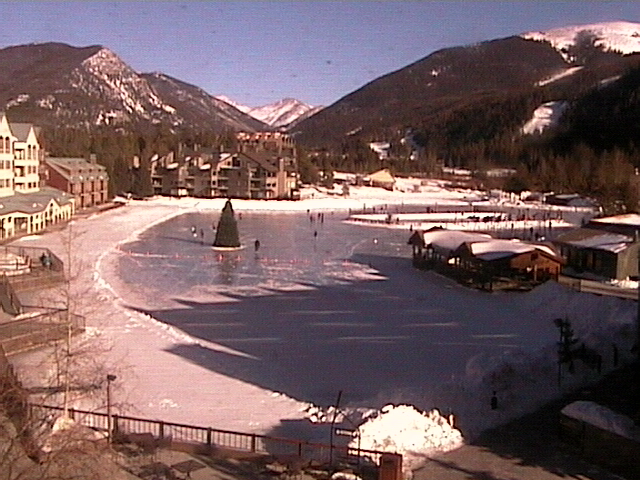
Lakeside Village
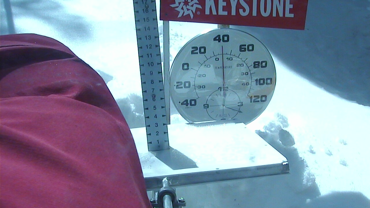
Snow Stake - 11,237 feet
SATURDAY
Feb 21
23° / 8°

7 - 15
mph
 0
0
SUNDAY
Feb 22
28° / 18°
7 - 15
mph
0
MONDAY
Feb 23

33° / 24°
7 - 15
mph
0
TUESDAY
Feb 24

34° / 25°

14 - 23
mph
0
WEDNESDAY
Feb 25
32° / 11°

29 - 40
mph
1
THURSDAY
Feb 26

29° / 20°
10 - 19
mph
0
Clear becoming partly cloudy at times continuing through overnight, with windy conditions at times.
No snow.
No precipitation expected.
Hi: 31°Low: 4°
975 feet to 8870 feet
Winds variable at 5 to 13 mph in the morning, becoming variable at 4 to 11 mph in the afternoon through overnight.
Clear becoming partly cloudy at times continuing through overnight, with windy conditions at times.
No snow.
No precipitation expected.
Hi: 14°Low: 3°
975 feet to 8870 feet
Winds W at 17 to 28 mph with gusts to 38 in the morning, becoming W at 28 to 39 mph in the afternoon, and then W at 23 to 34 mph with gusts to 45 overnight.
Clear becoming mostly clear in the late morning and then partly cloudy overnight. Expect windy conditions at times.
No snow.
No precipitation expected.
Hi: 35°Low: 12°
3,547 feet to 10039 feet
Winds variable at 4 to 12 mph in the morning, becoming variable at 4 to 11 mph in the afternoon, and then variable at 5 to 12 mph overnight.
Clear becoming mostly clear in the late morning and then partly cloudy overnight. Expect windy conditions at times.
No snow.
No precipitation expected.
Hi: 20°Low: 17°
3,547 feet to 10039 feet
Winds W at 21 to 32 mph with gusts to 38 in the morning, becoming NW at 26 to 37 mph in the afternoon through overnight.
Partly cloudy becoming mostly clear in the afternoon continuing through overnight, with windy conditions at times.
No snow.
No precipitation expected.
Hi: 40°Low: 20°
5,944 feet to 11199 feet
Winds variable at 5 to 13 mph in the morning, becoming variable at 5 to 12 mph in the afternoon, and then variable at 5 to 13 mph overnight.
Partly cloudy becoming mostly clear in the afternoon continuing through overnight, with windy conditions at times.
No snow.
No precipitation expected.
Hi: 25°Low: 21°
5,944 feet to 11199 feet
Winds W at 26 to 37 mph with gusts to 44 in the morning, becoming W at 27 to 38 mph with gusts to 44 in the afternoon, and then W at 39 to 50 mph with gusts to 58 overnight.
Mostly clear becoming partly cloudy in the afternoon continuing through overnight. Periods of snow are expected overnight.
Periods of light snow overnight. Snowfall is forecast to be a trace amount.
Potential Precip:
0 to 0.02
Hi: 42°Low: 25°
7,393 feet to 11438 feet
Winds NW at 7 to 15 mph through the day, becoming variable at 5 to 13 mph overnight.
Mostly clear becoming partly cloudy in the afternoon continuing through overnight. Periods of snow are expected overnight.
Periods of light snow overnight. Snowfall is forecast to be a trace amount.
Potential Precip:
0 to 0.02
Hi: 23°Low: 20°
7,393 feet to 11438 feet
Winds W at 41 to 52 mph with gusts to 59 through the day, becoming W at 42 to 53 mph with gusts to 61 overnight.
Partly cloudy becoming mostly cloudy at times and then clear overnight.
Periods of light snow throughout the day. Snowfall is forecast to be 1 to 2 inches.
Potential Precip:
0.03 to 0.17
Hi: 40°Low: 15°
4,247 feet to 10987 feet
Winds W at 16 to 27 mph with gusts to 40 through the day, becoming variable at 5 to 13 mph overnight.
Partly cloudy becoming mostly cloudy at times and then clear overnight. Periods of snow are expected in the morning through afternoon.
Periods of light to moderate snow throughout the day. Snowfall is forecast to be 2 to 4 inches.
Potential Precip:
0.03 to 0.17
Hi: 20°Low: 4°
4,247 feet to 10987 feet
Winds W at 51 to 62 mph with gusts to 73 through the day, becoming NW at 25 to 36 mph with gusts to 60 overnight.
Clear through the day and overnight, with windy conditions at times.
No snow.
No precipitation expected.
Hi: 36°Low: 19°
5,608 feet to 10259 feet
Winds variable at 5 to 13 mph throughout the day and into overnight.
Clear through the day and overnight, with windy conditions at times.
No snow.
No precipitation expected.
Hi: 18°Low: 14°
5,608 feet to 10259 feet
Winds W at 30 to 41 mph with gusts to 56 through the day, becoming NW at 36 to 47 mph with gusts to 54 overnight.
 Sunrise & Sunset

Lunar Calendar


 Snow Maps and Weather Stations in the Area
 ![]() 13in, past 6 days. Snow surface is packed powder and machine groomed
13in, past 6 days. Snow surface is packed powder and machine groomed
Snow report provided by SnoCountry
Plan your future trip using our temperature, snowfall, snow depth, and precipitation tool
 Day |
 High Temperatures |
 Low Temperatures |
 Precipitation |
 Snowfall |
 Snow Depth |
||||||||||||||
|---|---|---|---|---|---|---|---|---|---|---|---|---|---|---|---|---|---|---|---|
| Avg | High | Year | Low | Year | Avg | High | Year | Low | Year | Avg | Max | Year | Avg | Max | Year | Avg | Max | Year | |
| 1 | 33 | 51 | 1897 | 11 | 1902 | 1 | 23 | 1905 | -15 | 1896 | 0.055 | 0.72 | 1996 | 0.90 | 14.0 | 1996 | 19.4 | 47 | 2014 |
| 2 | 30 | 45 | 1906 | 14 | 1913 | 1 | 22 | 1905 | -16 | 1913 | 0.044 | 0.80 | 1893 | 0.69 | 8.0 | 1893 | 19.1 | 46 | 2014 |
| 3 | 28 | 41 | 1906 | 13 | 1899 | 2 | 23 | 1905 | -19 | 1913 | 0.058 | 1.08 | 1905 | 0.88 | 13.0 | 1905 | 19.4 | 48 | 2006 |
| 4 | 30 | 48 | 1904 | 8 | 1899 | -1 | 21 | 1907 | -25 | 1894 | 0.043 | 0.50 | 1989 | 0.68 | 5.9 | 1989 | 19.7 | 48 | 2006 |
| 5 | 31 | 41 | 1978 | 8 | 1899 | 3 | 27 | 1907 | -18 | 1903 | 0.073 | 1.48 | 1971 | 0.94 | 6.2 | 1989 | 19.6 | 50 | 2006 |
| 6 | 29 | 41 | 1908 | -6 | 1899 | -1 | 24 | 1907 | -34 | 1899 | 0.030 | 0.31 | 1958 | 0.56 | 5.3 | 1958 | 19.9 | 50 | 2006 |
| 7 | 28 | 48 | 1898 | -3 | 1899 | 0 | 15 | 1902 | -18 | 1899 | 0.048 | 2.35 | 1893 | 0.66 | 23.5 | 1893 | 19.7 | 48 | 2006 |
| 8 | 27 | 46 | 1907 | 9 | 1900 | -2 | 14 | 1902 | -12 | 1911 | 0.063 | 1.00 | 1893 | 0.84 | 10.0 | 1893 | 19.5 | 48 | 2011 |
| 9 | 25 | 40 | 1908 | 9 | 1905 | -1 | 15 | 1912 | -20 | 1894 | 0.075 | 0.80 | 1893 | 1.00 | 8.0 | 1893 | 20.0 | 47 | 2014 |
| 10 | 27 | 43 | 1907 | 9 | 1895 | -2 | 20 | 1912 | -22 | 1898 | 0.062 | 0.65 | 1893 | 1.01 | 10.0 | 1975 | 19.9 | 49 | 2014 |
| 11 | 27 | 47 | 1907 | -4 | 1895 | 1 | 27 | 1902 | -16 | 1894 | 0.055 | 0.53 | 1995 | 0.90 | 7.5 | 1971 | 20.2 | 50 | 2014 |
| 12 | 27 | 46 | 1904 | 5 | 1895 | -6 | 19 | 1902 | -37 | 1899 | 0.048 | 1.04 | 1995 | 0.74 | 14.0 | 1995 | 20.3 | 51 | 2014 |
| 13 | 29 | 44 | 1904 | 9 | 1903 | -2 | 22 | 1904 | -30 | 1905 | 0.047 | 0.51 | 1986 | 0.78 | 7.0 | 1995 | 21.0 | 50 | 2014 |
| 14 | 29 | 42 | 1907 | 10 | 1903 | -2 | 26 | 1910 | -30 | 1897 | 0.047 | 0.49 | 1956 | 0.76 | 7.0 | 1956 | 21.6 | 52 | 2014 |
| 15 | 31 | 46 | 1898 | 8 | 1903 | 1 | 23 | 1904 | -35 | 1895 | 0.058 | 0.62 | 1900 | 0.96 | 10.0 | 1900 | 22.0 | 50 | 2014 |
| 16 | 31 | 50 | 1907 | 5 | 1910 | 3 | 22 | 1904 | -15 | 1895 | 0.092 | 2.00 | 1894 | 1.18 | 9.0 | 2005 | 22.6 | 48 | 2014 |
| 17 | 31 | 47 | 1902 | 5 | 1910 | 1 | 29 | 1901 | -27 | 1900 | 0.068 | 0.70 | 1901 | 1.06 | 10.5 | 1901 | 22.4 | 46 | 2014 |
| 18 | 32 | 54 | 1896 | 14 | 1910 | 1 | 24 | 1901 | -19 | 1978 | 0.044 | 0.56 | 1976 | 0.66 | 6.0 | 1996 | 21.5 | 45 | 2014 |
| 19 | 33 | 62 | 1896 | 17 | 1978 | 2 | 22 | 1907 | -15 | 1893 | 0.090 | 2.00 | 1894 | 1.02 | 12.5 | 1901 | 22.1 | 44 | 2014 |
| 20 | 32 | 68 | 1896 | 12 | 1978 | 4 | 21 | 1901 | -18 | 1911 | 0.063 | 0.44 | 2014 | 0.98 | 7.5 | 1989 | 22.5 | 47 | 2014 |
| 21 | 32 | 70 | 1896 | 12 | 1911 | 4 | 18 | 1901 | -23 | 1913 | 0.068 | 0.84 | 1996 | 0.94 | 10.0 | 1996 | 23.1 | 48 | 2014 |
| 22 | 34 | 71 | 1896 | 13 | 1897 | 3 | 23 | 1904 | -16 | 1912 | 0.071 | 2.00 | 1894 | 0.75 | 8.3 | 1900 | 22.6 | 47 | 2014 |
| 23 | 32 | 51 | 1907 | 15 | 1893 | 2 | 29 | 1904 | -23 | 1897 | 0.058 | 0.57 | 2012 | 0.86 | 6.0 | 1967 | 23.3 | 47 | 2014 |
| 24 | 35 | 52 | 1896 | 12 | 1893 | 1 | 21 | 1904 | -20 | 1894 | 0.042 | 0.51 | 2009 | 0.53 | 5.7 | 2013 | 23.2 | 45 | 2014 |
| 25 | 34 | 54 | 1896 | 10 | 1893 | 7 | 34 | 1904 | -20 | 1893 | 0.066 | 0.81 | 1895 | 0.93 | 8.5 | 1972 | 23.4 | 44 | 2014 |
| 26 | 32 | 52 | 1904 | 13 | 1911 | 6 | 25 | 1905 | -12 | 1895 | 0.049 | 0.66 | 1987 | 0.72 | 9.0 | 1987 | 23.4 | 47 | 2008 |
| 27 | 34 | 52 | 1898 | 20 | 1903 | 4 | 33 | 1904 | -15 | 1897 | 0.073 | 1.00 | 1901 | 0.94 | 15.0 | 1901 | 22.7 | 45 | 2008 |
| 28 | 30 | 50 | 1897 | 9 | 1893 | 4 | 22 | 1904 | -16 | 1900 | 0.096 | 1.25 | 1896 | 1.21 | 14.5 | 1899 | 23.9 | 45 | 2008 |
Day |
High Temperatures |
Low Temperatures |
Precipitation |
Snowfall |
Snow Depth |
||||||||||||||
|---|---|---|---|---|---|---|---|---|---|---|---|---|---|---|---|---|---|---|---|
| Avg | High | Year | Low | Year | Avg | High | Year | Low | Year | Avg | Max | Year | Avg | Max | Year | Avg | Max | Year | |
| 1 | 25 | 53 | 1989 | -7 | 1994 | 2 | 21 | 1963 | -28 | 1985 | 0.085 | 0.61 | 1963 | 1.39 | 10.7 | 1963 | 37.7 | 61 | 1996 |
| 2 | 24 | 47 | 1992 | -8 | 1985 | 0 | 19 | 2003 | -32 | 2011 | 0.064 | 0.80 | 1893 | 0.90 | 8.0 | 1893 | 37.5 | 60 | 2006 |
| 3 | 24 | 44 | 1962 | 2 | 2011 | 0 | 18 | 1962 | -32 | 2011 | 0.066 | 1.80 | 1895 | 1.06 | 18.0 | 1895 | 37.5 | 62 | 2006 |
| 4 | 26 | 46 | 1989 | 6 | 2016 | 2 | 19 | 1963 | -18 | 2011 | 0.048 | 0.47 | 1989 | 1.14 | 13.0 | 1989 | 37.9 | 64 | 2006 |
| 5 | 28 | 45 | 1963 | 7 | 1985 | 2 | 22 | 1965 | -20 | 1985 | 0.062 | 0.51 | 1951 | 1.13 | 8.5 | 1951 | 38.5 | 63 | 1996 |
| 6 | 25 | 44 | 1993 | 0 | 1982 | 1 | 18 | 1978 | -28 | 1989 | 0.064 | 0.80 | 1893 | 1.02 | 9.0 | 2011 | 38.5 | 64 | 1951 |
| 7 | 25 | 46 | 2015 | -1 | 1896 | 2 | 20 | 2015 | -28 | 1989 | 0.047 | 0.75 | 1976 | 0.67 | 4.8 | 1967 | 38.2 | 61 | 1951 |
| 8 | 27 | 45 | 2015 | 9 | 2003 | 4 | 21 | 1960 | -20 | 1974 | 0.077 | 0.60 | 2008 | 1.35 | 12.0 | 2008 | 38.6 | 62 | 2011 |
| 9 | 27 | 47 | 1987 | 0 | 1896 | 3 | 20 | 2015 | -20 | 2011 | 0.104 | 1.80 | 1893 | 1.84 | 18.0 | 1893 | 39.9 | 63 | 2014 |
| 10 | 26 | 46 | 2015 | 1 | 1966 | 2 | 25 | 1962 | -22 | 2011 | 0.086 | 0.80 | 1893 | 1.52 | 9.0 | 2014 | 40.2 | 66 | 2014 |
| 11 | 25 | 45 | 1962 | 5 | 1981 | 2 | 23 | 1962 | -25 | 1981 | 0.078 | 0.52 | 1971 | 1.52 | 12.7 | 1971 | 40.3 | 69 | 2014 |
| 12 | 26 | 44 | 2016 | 0 | 1965 | 3 | 27 | 1962 | -18 | 1965 | 0.053 | 0.85 | 1995 | 1.13 | 16.0 | 1995 | 40.5 | 63 | 2014 |
| 13 | 28 | 46 | 2016 | 9 | 2004 | 4 | 25 | 2016 | -16 | 2004 | 0.085 | 0.69 | 1951 | 1.60 | 10.0 | 1995 | 41.1 | 67 | 2014 |
| 14 | 29 | 49 | 1982 | 5 | 1966 | 5 | 22 | 1979 | -12 | 2014 | 0.063 | 0.56 | 1986 | 1.42 | 9.0 | 1986 | 41.3 | 69 | 2014 |
| 15 | 27 | 45 | 1979 | 5 | 1966 | 4 | 22 | 2015 | -15 | 1964 | 0.090 | 0.55 | 1995 | 1.68 | 9.5 | 1995 | 42.0 | 67 | 2014 |
| 16 | 28 | 43 | 2011 | 4 | 1990 | 4 | 19 | 1961 | -17 | 1966 | 0.059 | 0.34 | 1955 | 1.21 | 7.6 | 1955 | 42.2 | 68 | 2014 |
| 17 | 28 | 42 | 2002 | 8 | 1960 | 4 | 21 | 1959 | -18 | 1988 | 0.069 | 0.60 | 1895 | 1.31 | 8.9 | 1959 | 42.3 | 62 | 2014 |
| 18 | 28 | 50 | 2016 | 7 | 1964 | 4 | 25 | 2016 | -14 | 1988 | 0.096 | 0.80 | 1895 | 1.51 | 8.0 | 1895 | 42.6 | 62 | 1962 |
| 19 | 28 | 47 | 2004 | 8 | 1955 | 3 | 24 | 1986 | -14 | 1955 | 0.077 | 0.70 | 1980 | 1.47 | 10.5 | 1980 | 43.1 | 63 | 1980 |
| 20 | 27 | 45 | 1981 | -2 | 1953 | 3 | 19 | 1986 | -25 | 1955 | 0.109 | 0.69 | 1986 | 1.77 | 10.8 | 1986 | 43.9 | 69 | 1986 |
| 21 | 27 | 48 | 1995 | 2 | 1953 | 2 | 22 | 1996 | -24 | 1953 | 0.098 | 1.11 | 1996 | 1.74 | 16.0 | 1996 | 44.5 | 73 | 1996 |
| 22 | 29 | 52 | 1995 | 9 | 1955 | 3 | 20 | 1996 | -19 | 1955 | 0.084 | 0.64 | 1999 | 1.45 | 12.0 | 1999 | 44.7 | 75 | 1996 |
| 23 | 27 | 47 | 1995 | 7 | 1955 | 3 | 19 | 1972 | -19 | 1975 | 0.076 | 0.69 | 1950 | 1.46 | 10.3 | 1950 | 44.3 | 63 | 1962 |
| 24 | 27 | 45 | 1995 | 5 | 2012 | 2 | 22 | 2009 | -19 | 1960 | 0.075 | 0.80 | 1895 | 1.19 | 12.0 | 2009 | 45.0 | 69 | 1996 |
| 25 | 29 | 47 | 1995 | 8 | 1960 | 4 | 19 | 1986 | -15 | 1960 | 0.058 | 0.85 | 2008 | 1.17 | 14.0 | 2008 | 45.0 | 66 | 2008 |
| 26 | 28 | 47 | 1986 | 6 | 2002 | 4 | 21 | 1986 | -20 | 2002 | 0.070 | 0.60 | 1893 | 1.17 | 6.5 | 1958 | 45.0 | 68 | 2008 |
| 27 | 27 | 48 | 2016 | 4 | 1964 | 3 | 17 | 2016 | -14 | 1971 | 0.058 | 0.48 | 1968 | 1.11 | 7.9 | 1968 | 45.0 | 64 | 2008 |
| 28 | 29 | 52 | 1993 | 5 | 1998 | 3 | 18 | 2004 | -22 | 1962 | 0.065 | 0.55 | 1950 | 1.20 | 8.0 | 1995 | 45.2 | 63 | 1996 |
 Mountain Base


