 Weston Ski T...
 Beaver Creek Resort
 Southeast
 WebCams
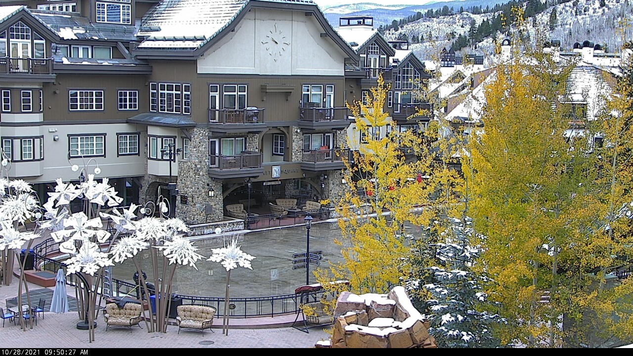
Family Ice Arena - 8,100ft
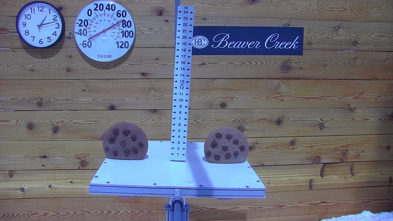
Snow stake -10,500'
TUESDAY
Apr 23

55° / 41°

7 - 15
mph
 0
0
WEDNESDAY
Apr 24

58° / 41°
5 - 13
mph
0
THURSDAY
Apr 25

44° / 35°
5 - 12
mph
0
FRIDAY
Apr 26
46° / 34°
0 - 0
mph
0
SATURDAY
Apr 27
41° / 27°
4 - 12
mph
3
SUNDAY
Apr 28
44° / 29°
6 - 14
mph
1
MONDAY
Apr 29
56° / 37°
5 - 13
mph
0
Mostly cloudy becoming mostly clear in the evening continuing through overnight, with periods of rain expected in the morning through evening.
No snow.
Potential Precip:
0.01 to 0.07
Hi: 56°Low: 42°
10,852 feet to 12973 feet
Winds SW at 8 to 16 mph in the morning, becoming S at 7 to 15 mph in the afternoon, and then SW at 7 to 15 mph overnight.
Mostly cloudy becoming mostly clear in the evening continuing through overnight, with periods of snow expected in the morning through evening.
Light snow through the day and into the evening. Snowfall is forecast to be a trace amount during the day, and a trace amount in the evening.
Potential Precip:
0.01 to 0.07
Hi: 37°Low: 33°
10,852 feet to 12973 feet
Winds W at 19 to 30 mph in the morning, becoming W at 22 to 33 mph in the afternoon, and then W at 21 to 32 mph overnight.
Partly cloudy becoming clear in the late morning continuing through overnight. Expect windy conditions at times.
No snow.
No precipitation expected.
Hi: 59°Low: 42°
11,958 feet to 13182 feet
Winds SW at 11 to 20 mph in the morning, becoming variable at 5 to 13 mph in the afternoon through overnight.
Partly cloudy becoming clear in the late morning continuing through overnight. Expect windy conditions at times.
No snow.
No precipitation expected.
Hi: 38°Low: 31°
11,958 feet to 13182 feet
Winds SW at 19 to 30 mph in the morning, becoming SW at 27 to 38 mph in the afternoon, and then SW at 13 to 22 mph with gusts to 34 overnight.
Mostly cloudy becoming partly cloudy at times continuing through overnight, with periods of rain and snow expected overnight.
Light snow in the evening through overnight. Snowfall is forecast to be a trace amount in the evening and overnight.
Potential Precip:
0.13 to 0.67
Hi: 45°Low: 37°
9,167 feet to 11035 feet
Winds variable at 5 to 13 mph in the morning, becoming variable at 5 to 12 mph in the afternoon, and then variable at 5 to 13 mph overnight.
Mostly cloudy becoming partly cloudy at times continuing through overnight, with periods of snow expected at any time.
Moderate snow with periods of heavy through the day, becoming moderate with periods of heavy in the evening and light overnight. Snowfall is forecast to be 2 to 3 during the day, and 4 to 6 inches in the evening and overnight.
Potential Precip:
0.13 to 0.67
Hi: 27°Low: 22°
9,167 feet to 11035 feet
Winds W at 10 to 19 mph in the morning, becoming W at 12 to 21 mph with gusts to 35 in the afternoon, and then W at 15 to 26 mph with gusts to 49 overnight.
Mostly cloudy becoming cloudy at times continuing through overnight, with periods of rain and snow expected overnight.
Periods of light snow throughout the day. Snowfall is forecast to be a trace amount.
Potential Precip:
0.12 to 0.58
Hi: 47°Low: 36°
8,852 feet to 11407 feet
Winds variable at 5 to 13 mph in the morning, becoming calm in the afternoon, and then variable at 5 to 12 mph overnight.
Mostly cloudy becoming cloudy at times continuing through overnight, with periods of snow expected in the morning through overnight.
Periods of moderate to heavy snow throughout the day, moderate at times overnight. Snowfall is forecast to be 4 to 6 inches.
Potential Precip:
0.12 to 0.58
Hi: 28°Low: 24°
8,852 feet to 11407 feet
Winds W at 10 to 18 mph in the morning, becoming variable at 5 to 13 mph with gusts to 21 in the afternoon, and then S at 6 to 14 mph overnight.
Mostly cloudy becoming partly cloudy at times continuing through overnight, with periods of rain and snow expected overnight.
Periods of light to moderate snow throughout the day, light at times overnight. Snowfall is forecast to be 2 to 4 inches.
Potential Precip:
0.33 to 1.64
Hi: 43°Low: 28°
6,696 feet to 10652 feet
Winds variable at 4 to 12 mph through the day, becoming variable at 5 to 13 mph overnight.
Mostly cloudy becoming partly cloudy at times continuing through overnight, with periods of snow expected at any time.
Periods of heavy snow throughout the day, moderate at times overnight. Snowfall is forecast to be 12 to 16 inches.
Potential Precip:
0.33 to 1.64
Hi: 26°Low: 16°
6,696 feet to 10652 feet
Winds NW at 10 to 18 mph with gusts to 28 through the day, becoming NW at 12 to 21 mph with gusts to 28 overnight.
Partly cloudy through the day and overnight.
Periods of light snow throughout the day. Snowfall is forecast to be a trace amount.
Potential Precip:
0.06 to 0.28
Hi: 45°Low: 30°
7,280 feet to 10895 feet
Winds W at 6 to 14 mph through the day, becoming variable at 5 to 13 mph overnight.
Partly cloudy through the day and overnight, with periods of snow expected in the morning through evening.
Periods of moderate snow throughout the day. Snowfall is forecast to be 3 to 5 inches.
Potential Precip:
0.06 to 0.28
Hi: 25°Low: 20°
7,280 feet to 10895 feet
Winds W at 13 to 24 mph with gusts to 34 through the day, becoming W at 15 to 26 mph with gusts to 41 overnight.
Partly cloudy becoming clear at times and then partly cloudy overnight. Periods of rain are expected in the morning.
No snow.
Potential Precip:
0.01 to 0.04
Hi: 57°Low: 38°
10,199 feet to 13393 feet
Winds variable at 5 to 13 mph throughout the day and into overnight.
Partly cloudy becoming clear at times and then partly cloudy overnight. Periods of snow are expected in the morning.
Periods of snow throughout the day and overnight.
Potential Precip:
0.01 to 0.04
Hi: 37°Low: 28°
10,199 feet to 13393 feet
Winds SW at 12 to 21 mph through the day, becoming SW at 9 to 18 mph with gusts to 24 overnight.
 Sunrise & Sunset

Lunar Calendar


advertisement

 Snow Maps and Weather Stations in the Area
 ![]() 16in, past 7 days. Snow surface is packed powder and powder
16in, past 7 days. Snow surface is packed powder and powder
Snow report provided by SnoCountry
Plan your future trip using our temperature, snowfall, snow depth, and precipitation tool
 Day |
 High Temperatures |
 Low Temperatures |
 Precipitation |
 Snowfall |
 Snow Depth |
||||||||||||||
|---|---|---|---|---|---|---|---|---|---|---|---|---|---|---|---|---|---|---|---|
| Avg | High | Year | Low | Year | Avg | High | Year | Low | Year | Avg | Max | Year | Avg | Max | Year | Avg | Max | Year | |
| 1 | 46 | 67 | 2012 | 28 | 2009 | 18 | 34 | 2001 | 0 | 2008 | 0.041 | 0.63 | 1985 | 0.72 | 7.0 | 1985 | 19.4 | 48 | 1996 |
| 2 | 48 | 65 | 2012 | 28 | 2009 | 21 | 33 | 2007 | 0 | 2008 | 0.054 | 0.38 | 2006 | 0.76 | 4.5 | 2006 | 18.8 | 47 | 1996 |
| 3 | 46 | 59 | 2011 | 35 | 2000 | 22 | 37 | 2004 | 10 | 2009 | 0.075 | 1.03 | 1989 | 1.06 | 11.0 | 1989 | 18.0 | 50 | 1993 |
| 4 | 46 | 61 | 1990 | 29 | 1999 | 20 | 28 | 2001 | 5 | 1988 | 0.058 | 0.65 | 2009 | 0.82 | 7.0 | 2009 | 16.4 | 46 | 1996 |
| 5 | 47 | 60 | 1990 | 31 | 2009 | 22 | 32 | 2007 | 5 | 2009 | 0.074 | 0.40 | 2005 | 1.15 | 7.5 | 2005 | 16.4 | 46 | 1996 |
| 6 | 47 | 60 | 2012 | 23 | 1997 | 20 | 33 | 2004 | -1 | 2009 | 0.056 | 0.73 | 2010 | 0.61 | 7.0 | 2010 | 14.9 | 45 | 1996 |
| 7 | 49 | 63 | 1988 | 28 | 1997 | 22 | 32 | 2004 | 0 | 2009 | 0.053 | 0.60 | 2003 | 0.86 | 8.0 | 2003 | 14.9 | 45 | 1993 |
| 8 | 49 | 65 | 1986 | 33 | 1993 | 22 | 34 | 1990 | 8 | 2009 | 0.049 | 0.59 | 1994 | 0.94 | 10.0 | 1994 | 14.5 | 46 | 1993 |
| 9 | 50 | 59 | 2016 | 32 | 1991 | 24 | 33 | 2007 | 11 | 2010 | 0.059 | 0.43 | 1995 | 0.62 | 4.0 | 1997 | 12.2 | 44 | 1993 |
| 10 | 47 | 63 | 2012 | 28 | 1995 | 23 | 29 | 1992 | 11 | 1991 | 0.075 | 0.32 | 2008 | 1.01 | 5.0 | 1993 | 13.2 | 48 | 1993 |
| 11 | 47 | 66 | 2012 | 29 | 2011 | 21 | 33 | 1992 | 7 | 1988 | 0.138 | 2.67 | 2001 | 1.44 | 16.5 | 2001 | 12.9 | 47 | 2008 |
| 12 | 46 | 66 | 2012 | 25 | 1997 | 21 | 32 | 2010 | 7 | 2008 | 0.068 | 0.49 | 1987 | 0.95 | 5.0 | 1991 | 11.6 | 45 | 1993 |
| 13 | 50 | 65 | 1992 | 27 | 1997 | 23 | 34 | 1990 | 6 | 2008 | 0.036 | 0.48 | 1986 | 0.72 | 8.0 | 1993 | 12.1 | 52 | 1993 |
| 14 | 51 | 66 | 1988 | 32 | 2014 | 23 | 38 | 1988 | 5 | 1987 | 0.042 | 0.55 | 2013 | 0.52 | 4.0 | 2013 | 10.0 | 45 | 1993 |
| 15 | 50 | 65 | 1990 | 34 | 2014 | 22 | 41 | 2002 | 12 | 1996 | 0.032 | 0.40 | 2012 | 0.42 | 7.0 | 2012 | 9.0 | 43 | 1993 |
| 16 | 49 | 68 | 1985 | 26 | 1999 | 23 | 30 | 2002 | 15 | 1999 | 0.127 | 1.00 | 2016 | 1.59 | 13.0 | 2013 | 8.9 | 43 | 1993 |
| 17 | 51 | 70 | 1985 | 27 | 1999 | 24 | 35 | 1992 | 4 | 1999 | 0.041 | 0.33 | 2016 | 0.50 | 4.0 | 1998 | 7.5 | 42 | 1993 |
| 18 | 52 | 66 | 1989 | 31 | 2013 | 25 | 33 | 2011 | 10 | 2013 | 0.082 | 0.48 | 1992 | 0.98 | 7.0 | 1995 | 9.1 | 41 | 1993 |
| 19 | 52 | 70 | 1987 | 22 | 2013 | 24 | 32 | 2001 | 12 | 2013 | 0.088 | 0.86 | 1996 | 0.78 | 6.0 | 1993 | 8.3 | 45 | 1993 |
| 20 | 50 | 71 | 1987 | 28 | 1996 | 26 | 36 | 2014 | 10 | 1996 | 0.055 | 0.39 | 1995 | 0.66 | 6.5 | 1995 | 7.5 | 48 | 1993 |
| 21 | 52 | 74 | 1989 | 33 | 2013 | 25 | 32 | 1997 | 15 | 1993 | 0.064 | 0.42 | 1997 | 0.70 | 5.0 | 1985 | 7.2 | 44 | 1993 |
| 22 | 53 | 71 | 1989 | 34 | 1997 | 25 | 35 | 1994 | 15 | 1996 | 0.087 | 1.40 | 2001 | 0.80 | 8.5 | 2001 | 7.6 | 41 | 1993 |
| 23 | 51 | 69 | 1986 | 34 | 2013 | 26 | 35 | 2014 | 12 | 2008 | 0.172 | 2.30 | 2000 | 1.18 | 8.0 | 2000 | 8.6 | 39 | 1993 |
| 24 | 53 | 74 | 1989 | 28 | 2013 | 27 | 35 | 2005 | 9 | 2013 | 0.141 | 1.35 | 2003 | 1.84 | 20.0 | 2003 | 8.7 | 41 | 1993 |
| 25 | 53 | 70 | 2012 | 40 | 1997 | 27 | 37 | 2009 | 15 | 2013 | 0.090 | 0.60 | 2005 | 0.93 | 8.0 | 1993 | 6.7 | 45 | 1993 |
| 26 | 53 | 71 | 1989 | 39 | 2008 | 25 | 32 | 1990 | 9 | 1988 | 0.093 | 0.52 | 1995 | 0.96 | 5.0 | 1995 | 6.3 | 37 | 1993 |
| 27 | 52 | 70 | 2012 | 37 | 1999 | 26 | 34 | 2012 | 20 | 1985 | 0.045 | 0.36 | 2012 | 0.18 | 2.0 | 1996 | 5.5 | 36 | 1993 |
| 28 | 56 | 70 | 2007 | 39 | 2011 | 26 | 35 | 1999 | 14 | 2011 | 0.037 | 0.34 | 2005 | 0.22 | 2.5 | 1994 | 4.7 | 33 | 1993 |
| 29 | 55 | 72 | 1992 | 31 | 1996 | 27 | 39 | 2016 | 14 | 2011 | 0.094 | 0.66 | 1990 | 1.04 | 11.0 | 2010 | 4.8 | 31 | 1993 |
| 30 | 53 | 74 | 1992 | 34 | 1990 | 27 | 36 | 2000 | 16 | 2011 | 0.104 | 0.53 | 1994 | 0.96 | 7.0 | 1991 | 4.8 | 30 | 1993 |
Day |
High Temperatures |
Low Temperatures |
Precipitation |
Snowfall |
Snow Depth |
||||||||||||||
|---|---|---|---|---|---|---|---|---|---|---|---|---|---|---|---|---|---|---|---|
| Avg | High | Year | Low | Year | Avg | High | Year | Low | Year | Avg | Max | Year | Avg | Max | Year | Avg | Max | Year | |
| 1 | 35 | 55 | 2012 | 16 | 2009 | 10 | 27 | 2012 | -11 | 2014 | 0.074 | 0.97 | 1980 | 1.07 | 9.0 | 1980 | 50.7 | 71 | 2011 |
| 2 | 36 | 53 | 2012 | 19 | 1979 | 11 | 27 | 1966 | -10 | 1987 | 0.086 | 0.58 | 1957 | 1.35 | 12.0 | 1957 | 50.4 | 69 | 1980 |
| 3 | 35 | 51 | 2011 | 18 | 1956 | 10 | 27 | 2011 | -10 | 1987 | 0.113 | 0.86 | 1952 | 1.88 | 9.0 | 1989 | 50.9 | 70 | 1980 |
| 4 | 34 | 52 | 1992 | 12 | 1955 | 11 | 28 | 1961 | -9 | 1973 | 0.064 | 0.47 | 2011 | 1.04 | 7.0 | 2011 | 50.7 | 72 | 2011 |
| 5 | 36 | 50 | 2004 | 13 | 1983 | 11 | 27 | 1967 | -9 | 1983 | 0.091 | 0.99 | 1951 | 1.47 | 13.5 | 1951 | 50.9 | 69 | 2011 |
| 6 | 37 | 59 | 2012 | 10 | 1983 | 13 | 32 | 1972 | -11 | 1983 | 0.094 | 1.20 | 1895 | 1.35 | 12.0 | 1895 | 50.7 | 74 | 1957 |
| 7 | 38 | 55 | 1991 | 18 | 2010 | 12 | 29 | 1963 | -9 | 1993 | 0.088 | 0.57 | 1962 | 1.49 | 10.3 | 1962 | 50.6 | 75 | 1957 |
| 8 | 36 | 53 | 1988 | 12 | 1973 | 11 | 26 | 1963 | -20 | 1973 | 0.097 | 1.07 | 1962 | 1.42 | 14.0 | 1958 | 50.4 | 78 | 1962 |
| 9 | 38 | 51 | 1977 | 9 | 1973 | 12 | 28 | 1996 | -8 | 1973 | 0.086 | 1.21 | 1962 | 1.13 | 8.0 | 1896 | 50.0 | 79 | 1962 |
| 10 | 37 | 54 | 1996 | 15 | 1973 | 13 | 27 | 2002 | -12 | 1989 | 0.081 | 0.47 | 1951 | 1.18 | 7.0 | 1993 | 49.8 | 78 | 1962 |
| 11 | 37 | 52 | 2012 | 16 | 1959 | 13 | 30 | 2012 | -5 | 1995 | 0.118 | 0.98 | 2001 | 2.12 | 15.5 | 2001 | 51.1 | 76 | 1962 |
| 12 | 36 | 56 | 2012 | 17 | 1953 | 12 | 28 | 1992 | -11 | 1953 | 0.117 | 0.94 | 1951 | 1.81 | 11.5 | 1951 | 51.2 | 75 | 1962 |
| 13 | 37 | 52 | 2006 | 21 | 1964 | 13 | 27 | 2010 | -6 | 1980 | 0.094 | 0.80 | 1893 | 1.60 | 22.5 | 1967 | 50.4 | 72 | 1984 |
| 14 | 38 | 53 | 2006 | 18 | 1987 | 14 | 29 | 1963 | -4 | 1983 | 0.051 | 0.60 | 2013 | 0.97 | 11.0 | 2013 | 49.6 | 68 | 1980 |
| 15 | 39 | 53 | 1962 | 21 | 1961 | 14 | 28 | 1971 | -5 | 1991 | 0.073 | 0.88 | 1950 | 0.94 | 10.5 | 1950 | 48.8 | 67 | 1970 |
| 16 | 40 | 52 | 1990 | 17 | 1999 | 16 | 30 | 1962 | -5 | 1973 | 0.075 | 0.75 | 2016 | 1.17 | 13.0 | 2016 | 48.4 | 66 | 1965 |
| 17 | 41 | 58 | 1989 | 14 | 1999 | 16 | 27 | 1985 | -7 | 1999 | 0.066 | 0.88 | 2008 | 1.04 | 12.0 | 2008 | 48.2 | 70 | 2008 |
| 18 | 41 | 57 | 1987 | 20 | 1896 | 16 | 28 | 1985 | -4 | 2013 | 0.107 | 0.82 | 1951 | 1.54 | 11.0 | 1995 | 47.7 | 67 | 2011 |
| 19 | 39 | 54 | 1962 | 21 | 1998 | 15 | 31 | 2001 | -4 | 2013 | 0.112 | 0.60 | 1894 | 1.80 | 9.0 | 2016 | 47.7 | 70 | 2011 |
| 20 | 38 | 55 | 1989 | 14 | 1973 | 13 | 32 | 1962 | -4 | 1975 | 0.082 | 0.90 | 1893 | 1.34 | 11.0 | 1971 | 47.7 | 73 | 1970 |
| 21 | 40 | 59 | 1989 | 20 | 1982 | 16 | 32 | 1960 | -4 | 1982 | 0.074 | 1.40 | 1895 | 0.99 | 14.0 | 1895 | 46.6 | 73 | 1970 |
| 22 | 41 | 57 | 1989 | 27 | 1984 | 17 | 31 | 1989 | 0 | 1987 | 0.081 | 0.62 | 2001 | 1.13 | 10.5 | 2001 | 46.0 | 72 | 1970 |
| 23 | 41 | 55 | 2016 | 24 | 1970 | 17 | 32 | 1965 | 0 | 1978 | 0.093 | 1.19 | 2000 | 1.38 | 16.0 | 2000 | 45.5 | 73 | 1970 |
| 24 | 42 | 56 | 2012 | 20 | 2013 | 18 | 34 | 2012 | 0 | 2013 | 0.084 | 1.55 | 2003 | 1.52 | 31.0 | 2003 | 45.3 | 75 | 2011 |
| 25 | 41 | 53 | 1981 | 20 | 1997 | 18 | 34 | 2012 | 5 | 2008 | 0.089 | 1.10 | 2005 | 1.30 | 14.0 | 1997 | 44.4 | 72 | 2011 |
| 26 | 41 | 56 | 1981 | 23 | 1969 | 17 | 34 | 2012 | -1 | 1984 | 0.117 | 0.69 | 1995 | 1.52 | 7.3 | 1988 | 44.2 | 77 | 2011 |
| 27 | 40 | 57 | 2003 | 19 | 1984 | 15 | 29 | 1981 | -4 | 1988 | 0.089 | 0.84 | 2015 | 1.51 | 9.6 | 1972 | 44.0 | 80 | 2011 |
| 28 | 41 | 54 | 2007 | 22 | 1984 | 16 | 28 | 2004 | -2 | 1994 | 0.057 | 0.69 | 1975 | 0.96 | 11.8 | 1975 | 43.4 | 74 | 2011 |
| 29 | 42 | 59 | 1992 | 21 | 1996 | 18 | 30 | 2007 | -3 | 1996 | 0.102 | 0.80 | 1952 | 1.48 | 11.0 | 2014 | 42.8 | 72 | 2011 |
| 30 | 42 | 58 | 1992 | 23 | 1962 | 18 | 32 | 2013 | 1 | 2010 | 0.116 | 1.47 | 1999 | 1.49 | 13.0 | 1999 | 42.5 | 78 | 2011 |
 Mountain Base


